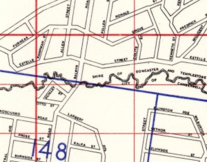
Balwyn Road is a major north-south thoroughfare through northern and central Boroondara.

History
The route of Balwyn Road can be traced back to the time of earliest European settlement in the area. It is shown as an unmade track in aerial images from as late as 1945.[1]
Balwyn Road once continued north into Bulleen to connect with Thompsons Road. Some time in the 1960s, the road was truncated at its present-day terminus at Carron Street.[2] The name 'Balwyn Road' is still given to its alignment north of the Eastern Freeway to this day.
Route
Beginning in Canterbury at a T-intersection with Canterbury Road, Balwyn Road immediately begins a steep ascent due north. This section is known for its large trees that are typical of this part of Boroondara and line both sides of the street.
The road continues north to the next signalised intersection at Mont Albert Road where the terrain becomes level on top of a hill. Once Balwyn Road reaches Fintona Girls' School, it steeply descents through the intersection with Whitehorse Road and down to Yarrbat Avenue in Balwyn. After crossing Belmore Road at the Belmore Heights Shopping Centre, it descends steeply into the Glass Creek valley and past Gordon Barnard Reserve to ascent steeply again to Doncaster Road.
After this point, its classification is downgraded to a 'collector' road and serves primarily local traffic. Once cresting the hill, it commences it steepest descent to Boroondara Primary School before levelling out at the Boroondara Shopping Centre. It then continues along a more gradual descent to Koonung Creek Reserve and the Eastern Freeway. Its name officially continues into Bulleen but there is no longer any direct road connection between the two separated parts.
Balwyn Road comprises one general traffic lane and one parking lane along its entire length. The section between Canterbury Road and Doncaster Road also features intermittent painted bicycle lanes between the traffic and parking lane.
References
- ↑ Victorian Department of Lands and Survey. Map Collection Melbourne 1945 Photo-maps. University of Melbourne:1945. http://maps-collection.library.unimelb.edu.au/historical/1945melb/, accessed: 24 June 2018
- ↑ Melway. MELWAY Edition 1. 1966. http://melwayed1.melway.com.au/mwyedn1.htm, accessed: 24 June 2018